Curiosity Plus Mapper
Professional Autonomous Mapping UAV

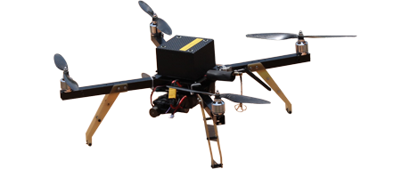
Curiosity Plus Mapper UAV
Curiosity Plus Mapper is a fully autonomous mini multicopter UAV specifically designed for professional aerial mapping, surveying, and 3D modeling. With 50 minutes endurance, 4 km range, and RTK GPS accuracy, it is the ideal solution for engineering surveys, construction monitoring, agriculture, and GIS applications. Made in India.
50 min
Endurance4.0 km
Range650 mm
Size300 g
PayloadTechnical Specifications
Physical Specifications
| Motor to Motor | 650 mm |
| Height | 250 mm |
| Flying Weight | 1995 g |
| Payload Capacity | 300 g |
| Propulsion | 180W BLDC Motors × 4 (14.8V) |
| Propeller | 15" Carbon Fiber × 4 |
| Battery | 14.8V 9600mAh Li-Ion |
Flying Characteristics
| Range | 4.0 km |
| Endurance | 50 minutes |
| Cruise Speed | 30 km/h |
| Max Wind Resistance | 20 km/h |
| Optimum Mapping Altitude | 120 m AGL |
| Max Altitude | 3000 m |
| Accuracy | Within 3 meters |
| Area Coverage | 1 km × 1 km per flight (at 120m) |
Capabilities
- Fully Autonomous from Takeoff to Landing
- Automatic Mapping Grid Generation
- Camera trigger only after reaching grid points
- Up to 500 Programmable Waypoints
- Loiter mode at any waypoint
- Manual override at any stage
- Click-to-Guide functionality
- Fail-safe Return to Home (RTH) & Auto Land
- Low battery & Lost link auto RTL
Autopilot System
- ARM Cortex M4 32-bit Processor @ 168 MHz with NuttX RTOS
- Triple redundant vibration damped IMU
- uBlox RTK GPS (Rover + Base)
- Triple redundant Magnetometer
- Dual Redundant High Resolution Barometer
- Onboard Micro SD Card for flight logging
- Inbuilt heating for sensors (low temperature operation)
Camera, Links & Standard Package
Survey Camera
| Camera | Canon Powershot with custom KAP_UAV firmware |
| Function | Geo-tagged stills for Pix4D / similar software |
| Compatibility | Any mapping camera ≤ 300g |
Communication Links
| Radio Control | 2400 MHz, 10 Channels, 5 km range |
| Data Link | MAV-Link Encrypted, 1000mW, 2400 MHz |
| RTK GPS | u-blox M8P with Survey-In base station |
Standard Package
- Curiosity Plus Mapper Aircraft × 1 (with RTK GPS)
- Ground Control Station with HD Video Display
- Android Tablet 7"
- Canon Powershot Camera (modified firmware)
- Radio Control Transmitter
- Dual Omni Antenna
- Microprocessor-based Battery Charger
- Mini Tool Kit & ABS Carry Case
Frequently Asked Questions
Click any question to expand the answer
It offers up to 50 minutes of flight endurance.
Operational range is 4.0 km. It can cover up to 1 km × 1 km area in a single flight at 120m altitude.
Yes. It features RTK GPS, automatic grid generation, and Canon Powershot with custom firmware for geo-tagged images compatible with Pix4D and similar software.
Yes, fully designed and manufactured in India by OM UAV Systems.
Note: Specifications subject to change without notice. All values are under ideal test conditions. Optional items affect pricing.
Ready to Deploy Curiosity Plus Mapper?
Contact our team for pricing, customization, and delivery timeline.